


RR
Ramesh Raju
Co-Founder

ASTROC AS Technology builds autonomous intelligent drones and unmanned ground vehicles for defence, government, agriculture, and infrastructure, fusing edge AI software, sensor networks, and robotic platforms into decisive operational outcomes. Designed and manufactured in India.
ASTROC platforms talk to each other. Edge AI, sensor fusion, and a unified command surface turn isolated assets into a single decisive intelligence.
We are a deep-tech company building the AI, sensor fusion, and autonomous command infrastructure that powers the next wave of uncrewed systems.
Our proprietary vision-based inertial navigation system enables uncrewed systems to operate entirely independently of GPS, so missions stay on course in contested electromagnetic environments.

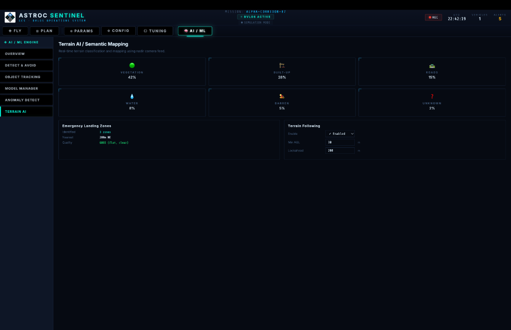
A multi-modal perception stack that unifies EO/IR, LiDAR, and radar data. Our algorithms provide robust, all-weather obstacle awareness and terrain mapping for complex, high-stakes deployments.

Real-time computer vision hardware and software integrated directly at the edge. We deliver sub-second latency for multi-class object detection, automated target recognition, and pose estimation without relying on cloud connectivity.

Our live geospatial intelligence platform built for the Indian command theater. Chakravyuh pulls open-source signals across social media, airspace transponders, and maritime feeds, correlates them through an NLP entity graph, and renders a unified threat picture on a single tactical map. Named after the ancient battle formation that no adversary could escape. Built so no signal does either.
Explore Chakravyuh ↗
We build our mission autonomy software entirely in-house. This indigenous stack powers the flight control computers of our UAVs, the auto-navigation routing of tactical UGVs, and the augmented reality feeds of our Smart Glasses, with complete Indian data sovereignty maintained across all domains.


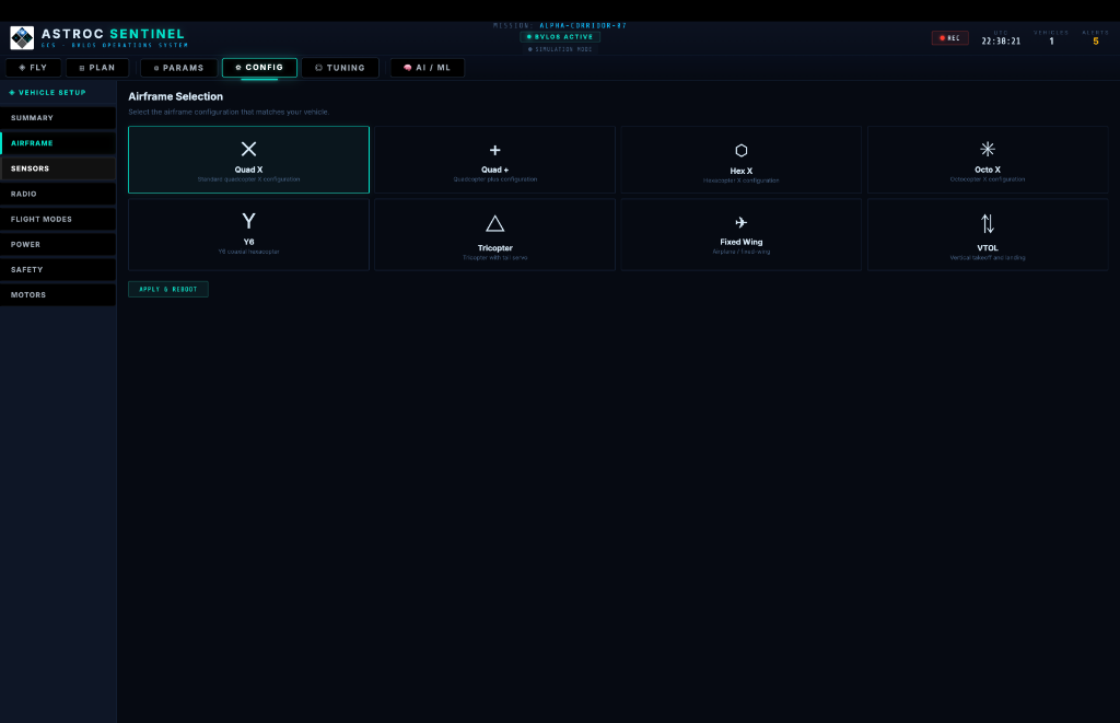
Our flagship Ground Control System. A mission-critical command interface providing real-time telemetry, AI-driven decision support, and multi-sensor fusion for defence and tactical operations.
Generic, off-the-shelf ground control applications rely on open-source codebases, exposing critical infrastructure to cyber risks. ASTROC Sentinel is engineered from the ground up as a fully indigenous, closed-loop command interface. We guarantee uncompromising data sovereignty, secure encrypted telemetry, and unified multi-vehicle coordination without the risks of open-market alternatives.


Live altitude, speed, battery, GPS, and HDOP monitoring. Multi-band C2 link with 4G LTE primary and RC 915 MHz backup.
Interactive waypoint management with corridor-based BVLOS flight planning, geofencing, and NFZ awareness.
Simultaneous EO/IR, nadir, and front camera feeds. Thermal imaging for surveillance and precision agriculture.
On-board automated target recognition, multi-class object detection, and threat assessment powered by edge AI.
Anti-jamming protocols, AES-256 encrypted telemetry, and autonomous return-to-base failsafes for contested environments.
Unified command of heterogeneous assets (UAVs & UGVs). Coordinate complex, multi-axis autonomous missions from a single pane of glass.
Visual-inertial odometry and on-board sensor fusion enable mission continuity in contested electromagnetic environments where GPS is jammed or spoofed.
Frame-perfect mission timeline recording, searchable telemetry archives, and audit-grade event logs for command-level after-action review.
Autonomous intelligent drone systems engineered for precision, reliability, and mission-critical performance.
TACTICAL RECONNAISSANCE
HD photography drone built for high-resolution aerial imaging. Lightweight, efficient, and cleared for both tactical operations and BVLOS missions.

MULTI-MISSION PLATFORM
Versatile quad-rotor platform for agriculture, surveillance, and mapping operations. Built for extended endurance and payload flexibility.

HEAVY-LIFT HEXACOPTER
Defence-grade heavy-lift platform for cargo delivery, agricultural spraying, and long-range surveillance missions across challenging terrains.


UNMANNED GROUND VEHICLE
RAKSHAK is ASTROC AS Technology's indigenous unmanned ground vehicle (UGV), designed and built in Hyderabad. Ruggedised and AI-powered, it is engineered for perimeter patrol, hazardous environment inspection, and tactical payload delivery.

End-to-end autonomous deployments for defence, infrastructure, and enterprise.
Our software powers real-time decisions across critical sectors, from precision agriculture to defence-grade surveillance. Indigenous technology, built in India.
Deep-tech leadership grounded in engineering execution, not narrative.

SreeHarsha Pandula is the Founder, Director, and CTO of ASTROC AS Technology - a Hyderabad-based deep-tech company building indigenous drones, unmanned ground vehicles (UGVs), and AI-driven autonomous systems for India's defence, government, agriculture, and infrastructure sectors. His work integrates artificial intelligence, machine learning, and computer vision into drone ecosystems, enabling terrain-aware navigation, GPS-denied operations, and real-time decision-making across active deployments with DRDO, the Andhra Pradesh government, and Syngenta.
Under his leadership, ASTROC has secured a SCOMET license for regulated strategic exports, filed intellectual property under DRDO secrecy clauses, and was selected to the AWS Space Accelerator cohort of 67 startups across Australia, India, and Japan. The company and its work have been featured in Forbes India, The Hindu, Hindustan Wires, and The Hindu BusinessLine.
"India's autonomy cannot depend on imports, it must be built domestically."
Real-world operational deployments validating our autonomy stack.

Challenge: Navigating complex urban airspace for municipal
payloads.
Solution: precision automated flight patterns utilizing ASTROC flight
controllers.
Impact: Efficient vector control and terrain mapping across Hyderabad.

Challenge: High-latency target identification relying on cloud
infrastructure.
Solution: Deployed customized YOLO models directly on edge computing
hardware.
Impact: Sub-second threat identification linking vehicles to secure
databases without external networks.
 Navigation
Challenge: Nighttime low-altitude flights in undulating, hazardous
terrain.
Solution: Real-time fusion of EO, thermal, and LiDAR streams processed
on-board.
Impact: Zero-incident BVLOS mapping across challenging topographies.
Challenge: Vulnerable GPS reliance in highly contested
zones.
Solution: Proprietary vision-inertial odometry integrated into Sentinel
GCS.
Impact: Achieved continuous autonomous flight and landing despite active RF
jamming.

Challenge: Manual operator fatigue during persistent
overwatch.
Solution: Continuous AI model processing detecting anomalies and distinct
profiles.
Impact: Automated alerts pushed directly to command interfaces.
 AI / Defence
Challenge: Identifying hostile intent in crowded
environments.
Solution: Advanced kinetic modeling and human pose
estimation.
Impact: Predictive threat assessment for pre-emptive security measures.

Challenge: Monitoring vast, inaccessible timber reserves.
Solution:
Persistent thermal overwatch and wide-area photogrammetry.
Impact: Rapid interdiction
of illegal operations and early fire detection.
Challenge: Slow manual surveying of extensive transit
arteries.
Solution: High-speed BVLOS corridor mapping yielding digital
twins.
Impact: Accelerated infrastructure development and structural integrity
analysis.
Challenge: Detecting minute sub-string faults across macro-scale solar grid
infrastructure.
Solution: Automated radiometric thermal sweeps processed by CV
algorithms.
Impact: Yield optimization and mitigation of cascading thermal failures.
Telecom
Challenge: Hazardous manual inspections of high-voltage transmission
towers.
Solution: Close-proximity drone operations using on-board collision avoidance.
Impact: Zero personnel risk combined with 3D structural degradation alerts.

Challenge: Delivering export-ready, sovereign autonomous capabilities
globally.
Solution: Custom hardware/software integration and demonstrations at the
Dubai Airshow.
Impact: Validated ASTROC as a reliable indigenous partner for
international procurement.

Challenge: Extracting actionable traffic intelligence from raw dashcam
footage.
Solution: Multi-stage AI pipeline with vehicle detection, ANPR, pedestrian
analytics, and traffic sign recognition at 29+ FPS.
Impact: 5,500+ detections per
corridor pass with automated anomaly alerts.
Cultivating the next generation of aerospace engineers and autonomous systems operators.
STEM outreach program accelerating knowledge transfer regarding orbital mechanics, advanced telemetry, and core space technologies.
Specialized Remote Pilot Training Operations (RPTO) so operators can confidently work with advanced ISR and payload-delivery platforms.
Rigorous, hands-on modules demonstrating model compression for edge deployment, secure ground control integration, and flight-stack engineering.
National media coverage validating ASTROC's role in India's deep-tech evolution.
Read on Hindustan Wires →At a time when much of the startup ecosystem is driven by visibility, valuation, and velocity, a different kind of company is taking shape. ASTROC is not structured as a conventional startup. It operates as a systems company, building across hardware, software, analytics, and deployment frameworks. Its intellectual property filings, including those under the DRDO secrecy clause, indicate work that extends into domains of long-term strategic relevance.
ASTROC AS Technology is building India's indigenous backbone for autonomous systems across defence, agriculture, and infrastructure. Holding a rare SCOMET license, ASTROC is among a select group authorised for strategic exports. With new UGV platforms and AI frameworks built for GPS-denied environments, the company is positioned at the forefront of India's deep-tech evolution.
Read on Forbes India →"India's autonomy cannot depend on imports, it must be built domestically."
- SreeHarsha Pandula, Founder & CEO, ASTROC AS Technology
ASTROC operates as a systems company, combining hardware, software, and analytics across drones, AI-powered GIS mapping, and autonomous platforms. The RAKSHAK UGV, developed in alignment with DRDO requirements, reflects engineering depth built for strategic relevance, not demonstration. ASTROC's autonomous systems are already being evaluated for strategic international deployment.
Read on The Hindu →"We are building systems that function where infrastructure fails. That is the real test of deep tech."
- SreeHarsha Pandula, Founding Director & CTO, ASTROC AS Technology
ASTROC was named among 67 startups across Australia, India, and Japan selected for the AWS Space Accelerator program, a competitive cohort recognising deep-tech ventures advancing space-grade autonomous systems, sensor fusion, and GPS-denied navigation platforms.
Trusted by premier defence organizations and law enforcement to deploy mission-critical autonomy at the tactical edge.
Providing indigenous sensor fusion, secure telemetry, and flight control systems to prime contractors and research agencies.
Deploying edge AI vision, crowd analytics, and autonomous perimeter patrol systems for state security apparatus.
ASTROC AS TECHNOLOGY PVT. LTD.
Ground floor and first floor, unit-02
Industrial Park, Uppal,
500039
Telangana, India
DGCA Compliance
Defence Certifications from USA (Hardware, Software & Data Integrity)
STPI
Octane
Make in India Certified
MSME & Startup India Registered